#122478 - 23/10/2002 06:01
 Moving Maps on empeg...
|
addict

Registered: 09/06/1999
Posts: 559
Loc: Newfoundland, Canada
|
I have been reading these GPS threads with great interest. Only last week I interfaced my Magellan GPS 315 with my computer using a freeware program called GPS TrackMaker ( www.gpstm.com). This program allows importation of any map image (or 'any' image for that matter) and lets you give it the upper left coordinates and lower right coordinates for that image. I have found a number of sources of free maps since then... some in vector format and some in raster format. They all work great and most (all???) or the vector format maps have the coordinates included in the file.
For a neat list of maps of Canada go to toporama.cits.rncan.gc.ca Toporama... this site has topographic maps of all of canada in Gif format and at a fairly high resolution.
Another site with some great maps is ESRI at www.esri.com/data/online/esri/wobmselect.html. These are in vector format.
The last of these sites that I have found useful is at www.maproom.psu.edu/cgi-bin/dcw/dcwarea.cgi?North_America These are also in vector format. This link only shows the North America Maps available but I am sure that you can follow links to find worldwide data.
These images and datasets were all pulled into GPS TrackMaker without a problem and lets me have moving map software on my laptop... I don't think it would be too hard to emulate the way this software works in terms of moving map software on the empeg. (Please keep in mind that I am not a programmer... but to me it seems that all you need is a way to get these images into the gpsapp system)
Hope this stirs up some interest in this idea. 
Rene
P.S. Please... someone come up with an easy way to install these apps on my empeg... I've played empacman... but only after running it over hyperterminal... then it's lost on reboot. 
_________________________
12 gig empeg Mark II, SN: 080000101 30 gig RioCar SN: 30103114 My blog
|
|
Top
|
|
|
|
|
#122479 - 23/10/2002 06:35
Re: Moving Maps on empeg...
[Re: ShadowMan]
|
carpal tunnel

Registered: 25/12/2000
Posts: 16706
Loc: Raleigh, NC US
|
Yes, but none of these have data about roads, AFAICS. And without road information, pathfinding is impossible, unless you've got a four-wheeler.
_________________________
Bitt Faulk
|
|
Top
|
|
|
|
|
#122480 - 23/10/2002 06:45
Re: Moving Maps on empeg...
[Re: wfaulk]
|
addict
Registered: 09/06/1999
Posts: 559
Loc: Newfoundland, Canada
|
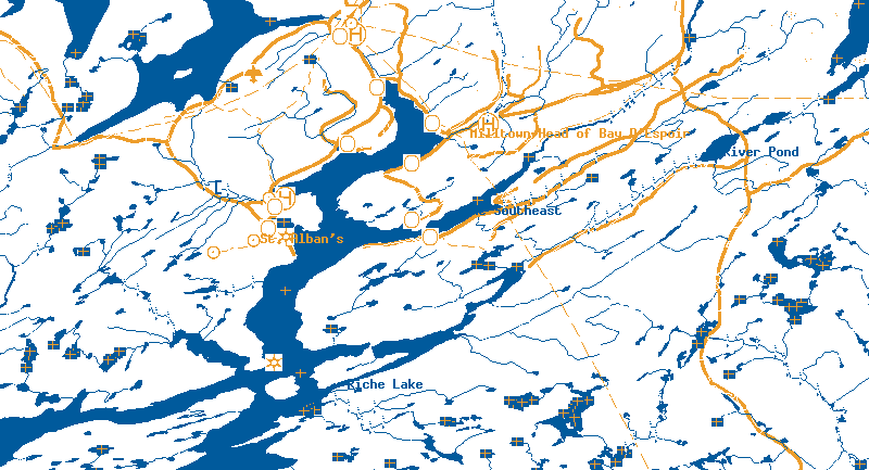
But they do have roads.. the Toporama maps in particular do have nicely laid out roads. As for the other ones they have road data as well... at least in what I have downloaded they do.
I am not thinking so much about using these maps in the way the mapsonus information is used... but more so to keep you from getting lost. I have downconverted the toporama maps to 4 colours... dark blue for water and some place names, black for some other place names, white for land and orange for the roads. these colors should translate fairly well over to the empeg... maybe replacing the Black place names with the orange color so that the viewability on the empeg would be better (some black place names are on the dark blue water).
Sound doable?
See attachment of a part of a map of my area... with a confluence point in the upper left corner
http://empeg.comms.net/files/121056-001m-4colours-snipped.gif
_________________________
12 gig empeg Mark II, SN: 080000101 30 gig RioCar SN: 30103114 My blog
|
|
Top
|
|
|
|
|
#122481 - 23/10/2002 09:24
Re: Moving Maps on empeg...
[Re: wfaulk]
|
carpal tunnel

Registered: 20/12/1999
Posts: 31636
Loc: Seattle, WA
|
Yes, but none of these have data about roads, AFAICS. And without road information, pathfinding is impossible, unless you've got a four-wheeler.
And even with the road data (as he illustrated) without detailed data about things like one-way roads, onramps, and bridges, pathfinding is still impossible.
However, a hybrid system, where we get the pre-calculated path from MapsOnUs, and project that path onto a moving map derived from one of these kinds of sources, might be useful.
|
|
Top
|
|
|
|
|
#122482 - 26/10/2002 06:15
Re: Moving Maps on empeg...
[Re: tfabris]
|
journeyman
Registered: 16/02/2000
Posts: 94
Loc: UK - NE Wales
|
Unless I'm mistaken, he doesn't want (automatic) pathfinding but just a simple scrolling map centered on the current location. This should be possible I think.
|
|
Top
|
|
|
|
|
#122483 - 26/03/2003 08:23
Re: Moving Maps on empeg...
[Re: FlibblE]
|
new poster
Registered: 06/03/2002
Posts: 39
Loc: Mississauga, Ontario, Canada
|
YES !!! that's what I would want too
Just a detailed image of Ontario scrolling around on my EMPEG screen. Is this possible yet ?
_________________________
 blue 2 X 30GB blue 2 X 30GB
|
|
Top
|
|
|
|
|
#122484 - 26/03/2003 09:35
Re: Moving Maps on empeg...
[Re: Rafy]
|
enthusiast
Registered: 20/08/2002
Posts: 340
Loc: Pittsburgh, PA
|
It is definitely possible, and in some ways almost trivial. But clearly nobody really cares enough about it.
First problem you have to tackle is that a map contains a lot of information. And the empeg display only has a certain amount of pixels to display it with. You can replace the escher image with a map image and see what the result is. From what I've tried it is either too cluttered, or such a small area that it becomes unusable for navigation.
Another problem is how to georeference the image, there are about as many ways to provide georeferencing information as there are sources for map images. And ofcourse everybody comes up with their own method, so I guess it would be no problem to invent your own. Given the georeferencing information you can do a simple matrix transformation to project the 3 dimensional gps coordinates into the 2 dimensional coordinate space of the image. Then you know exactly which pixel in the image should be in the center of the screen and copy the visible bytes over.
_________________________
40GB - serial #40104051 gpsapp
|
|
Top
|
|
|
|
|
#122485 - 26/03/2003 11:05
Re: Moving Maps on empeg...
[Re: jaharkes]
|
Carpal Tunnel

Registered: 08/02/2002
Posts: 3411
|
Hmm...I asked for this a long time ago. IIRC, I said "Give me a map and tell me where I am, and I'll neve get lost." So I don't think it's fair to say that no-one is interested.
Another point to consider is that this functionality could conceivably be a step on the path to the full routing navigation that many want. Even if most or all of the code developed on this step needed to be discarded and re-written due to data changes if/when full routing where implemented, I'd argue that you would have discovered more about what works and what doesn't wrt displaying and moving maps on the empeg's screen.
_________________________
Mk2a 60GB Blue. Serial 030102962
sig.mp3: File Format not Valid.
|
|
Top
|
|
|
|
|
#122486 - 26/03/2003 11:53
Re: Moving Maps on empeg...
[Re: genixia]
|
enthusiast
Registered: 20/08/2002
Posts: 340
Loc: Pittsburgh, PA
|
So I don't think it's fair to say that no-one is interested.
Ok, nobody is interested enough to actually implement this.
Another point to consider is that this functionality could conceivably be a step on the path to the full routing navigation that many want. Even if most or all of the code developed on this step needed to be discarded and re-written...
Ehh, the code is already there, take empan for the display an image on the screen part and mix in the stuff from gpsapp that talks to the GPS. You can even use the built-in imagepan visual or empan for mockups to visualize how such a display would work before implementing anything. But it doesn't provide anything useful for doing full routing on the empeg.
You need vector data to do routing. And it is not hard to use that same vector data to draw a map, or give you the coordinates of a an address/zipcode. Technically the route display in gpsapp already draws 2 lines out of such a vector dataset, the route we're following and the track that we've driven. A scrolling image doesn't help in either of these two areas and as such is not interesting in my opinion.
_________________________
40GB - serial #40104051 gpsapp
|
|
Top
|
|
|
|
|
#122487 - 26/03/2003 13:24
Re: Moving Maps on empeg...
[Re: jaharkes]
|
carpal tunnel

Registered: 27/06/1999
Posts: 7058
Loc: Pittsburgh, PA
|
I'm not a GPSapp user, but I am quite familiar with the limitatations of the empeg's display, and at one point did try to view a few maps of my area using empan. The results were far less than spectacular. I have to side with Jan here and say that the utility of a moving map on a 128x32x4 is questionable at best.
|
|
Top
|
|
|
|
|
#122488 - 26/03/2003 14:01
Re: Moving Maps on empeg...
[Re: tfabris]
|
old hand
Registered: 09/01/2002
Posts: 702
Loc: Tacoma,WA
|
I've been playing with Street Atlas 2003, trying to find a way to use it's maps as a source for GPSApp routes. Along the way I've come up with an interesting idea with regard to maps: We could theoritically use a program like Street Atlas to glean vector maps from an area. You can do this by simulating the proper mouse and keystrokes to bring up a map section, take a screenshot of the map. Then you parse this map (which follows a predictable raster format) into vector format roads. Lat/Lon information can be easily read for each map section from the interface of the program giving you a pixel to distance scale you can use. It's looking like I'm going to have to write a program that basically does this to get SA2003 routes into GPSApp routes. However, along the way my program could also get adjancent roads in the route, or even roads in an entire area. The only limitations on this method would be time (i.e. this would be slow) and disk space. On the copyright front, this may not be exactly up and up, but if we didn't distribute the maps, and just generated them ourselves, then it's just a form of "backup". So any interest in this scheme? This still won't allow for point-to-point routing on the empeg, but let's face it folks that ain't gonna happen (not without commercial support)- this scheme would though allow for easily displayable vector maps of an area.
|
|
Top
|
|
|
|
|
#122489 - 26/03/2003 14:39
Re: Moving Maps on empeg...
[Re: siberia37]
|
carpal tunnel
Registered: 25/12/2000
Posts: 16706
Loc: Raleigh, NC US
|
The only limitations on this method would be time (i.e. this would be slow) and disk space. Would it be able to figure out one-way roads?
_________________________
Bitt Faulk
|
|
Top
|
|
|
|
|
#122490 - 26/03/2003 14:59
Re: Moving Maps on empeg...
[Re: wfaulk]
|
old hand
Registered: 09/01/2002
Posts: 702
Loc: Tacoma,WA
|
>Would it be able to figure out one-way roads?
No but like I said the point isn't point-to-point routing it's just getting a vector format map, which has many advantages over raster (i.e. zoomable).
|
|
Top
|
|
|
|
|
#122491 - 26/03/2003 15:14
Re: Moving Maps on empeg...
[Re: genixia]
|
new poster
Registered: 06/03/2002
Posts: 39
Loc: Mississauga, Ontario, Canada
|
I'm with genixia !
Give me a map and tell me where I am on it and i'll never get lost.
Routing is great but only if you know where you're going. To be honest, When I go for a drive with my GF I never know where i'm going to end up. I just need to know where I am at the time and what roads/hws near by I can take.
I've seen a panning map image on the empeg screen and I thought it looked pretty good ... good enough.
_________________________
blue 2 X 30GB
|
|
Top
|
|
|
|
|
#122492 - 26/03/2003 18:03
Re: Moving Maps on empeg...
[Re: jaharkes]
|
carpal tunnel

Registered: 24/01/2002
Posts: 3937
Loc: Providence, RI
|
Ok, nobody is interested enough to actually implement this.
I did a small amount of work and then determined 128x32 wasn't big enough to represent any data I cared about.
Technically the route display in gpsapp already draws 2 lines out of such a vector dataset, the route we're following and the track that we've driven. A scrolling image doesn't help in either of these two areas and as such is not interesting in my opinion.
After determining what I was going to be able to see, I came to the same conclusion.
|
|
Top
|
|
|
|
|
#122494 - 27/03/2003 06:57
Re: Moving Maps on empeg...
[Re: Rafy]
|
addict
Registered: 09/06/1999
Posts: 559
Loc: Newfoundland, Canada
|
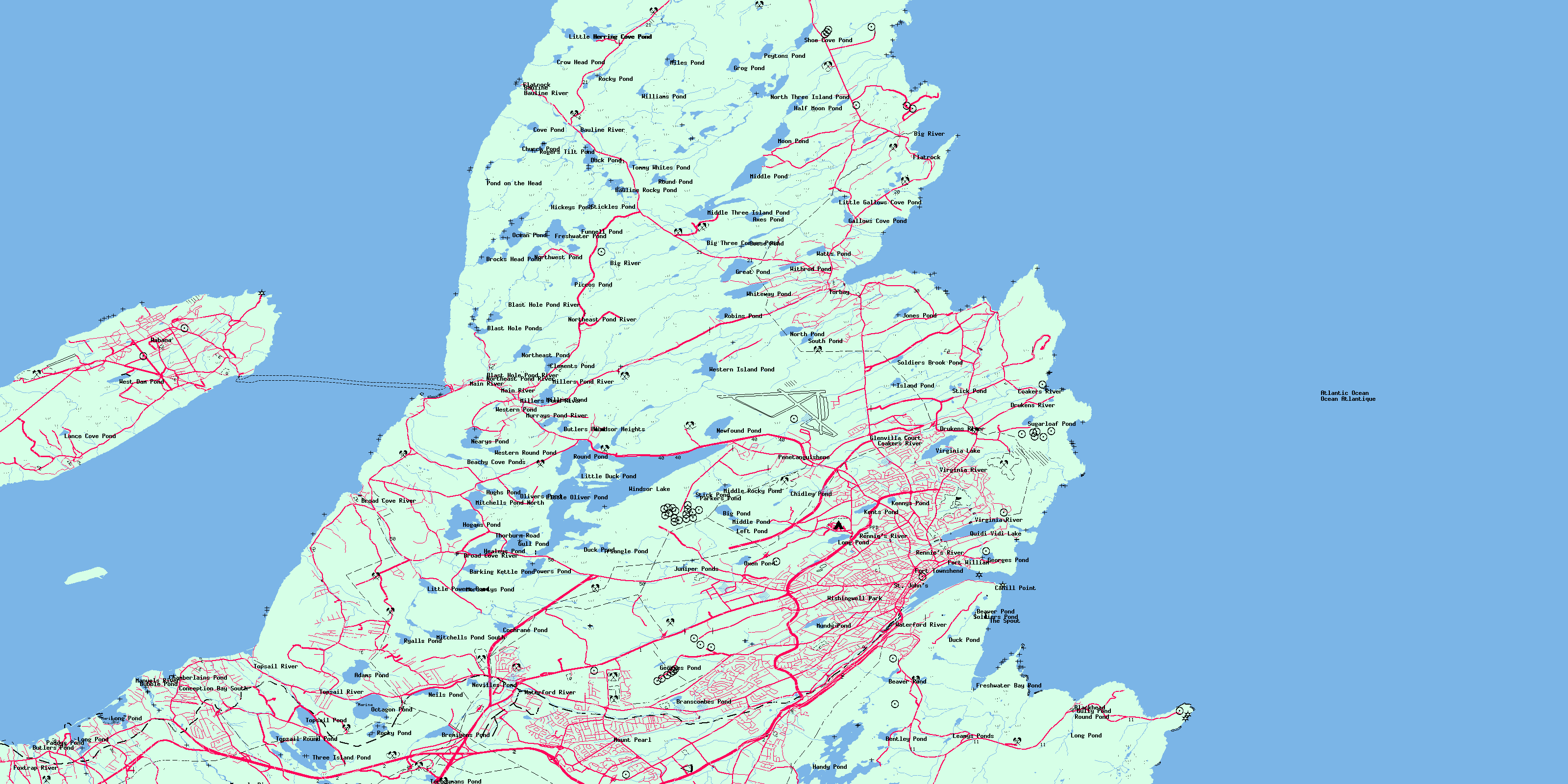
I want this sooooo bad. I have attached a 4 colour reduction of area 001n10 from Toporama. It is a 1:50,000 scale map and weighns in at less then 200k.
The upper left hand coordinate of the map is -53 and 47.75 and the lower right coordinates are -52.5 and 47.5. With this map and both coordinates we can interpolate all coordinates in between. Using this along with GPSApp and my GPS interfaced to my empeg I can see where I am and what that pond to my left is named. Give me a map and I can get out of where I am, as long as I know where I am. I don't need routing information. I am also not what anybody would call a good programmer... I did three semesters with Modula 2!
Anybody who can implement this and has a Paypal account might have a few donations come their way.
Attachments
149064-001n10 reduced to 4 colours.gif (98 downloads)
_________________________
12 gig empeg Mark II, SN: 080000101 30 gig RioCar SN: 30103114 My blog
|
|
Top
|
|
|
|
|
#122495 - 27/03/2003 07:09
Re: Moving Maps on empeg...
[Re: ShadowMan]
|
addict
Registered: 09/06/1999
Posts: 559
Loc: Newfoundland, Canada
|
Let's see if this attachment works (the other one didn't, at least not for me.)
And incase anybody wants it, the Ottawa Area 1:50,000 is at http://toporama.cits.rncan.gc.ca/images/b50k/03/031g05.gif
It's upper left coordinates are -76 and 45.5 and the lower right coordinates are -75.5 and 45.25
_________________________
12 gig empeg Mark II, SN: 080000101 30 gig RioCar SN: 30103114 My blog
|
|
Top
|
|
|
|
|
#122496 - 27/03/2003 07:15
Re: Moving Maps on empeg...
[Re: ShadowMan]
|
addict
Registered: 14/01/2002
Posts: 443
Loc: Raleigh, NC
|
Keep in mind that you can only see 128x32 sections of this map. Then tell me this would be better than a paper map.. 
|
|
Top
|
|
|
|
|
#122497 - 27/03/2003 07:39
Re: Moving Maps on empeg...
[Re: Yang]
|
addict
Registered: 09/06/1999
Posts: 559
Loc: Newfoundland, Canada
|
I didn't say it would be better then a paper map. But it would be a lot more convenient then lugging them around. I usually don't need maps here in Newfoundland anyways but this would rock as far as I am concerned. With a pan and scan feature you could move all around the map and check out what's around you. It could even be possible that you could zoom out to the 1:250,000 topo maps as well, giving you a bigger, less detailed, overall view. Does having the lyrics displayed on your empeg screen really add any usefuleness to the empeg? In most cases - nope (unless you want to prove someone wrong when they get lyrics all screwed up). But I can tell you one thing, having the lyrics on the screen frickin' rocks! I also think that having the moving map would frickin' rock!
Rene
_________________________
12 gig empeg Mark II, SN: 080000101 30 gig RioCar SN: 30103114 My blog
|
|
Top
|
|
|
|
|
#122498 - 28/03/2003 07:53
Re: Moving Maps on empeg...
[Re: Yang]
|
new poster
Registered: 06/03/2002
Posts: 39
Loc: Mississauga, Ontario, Canada
|
I think 128x32 is not much different from a palm pilot screen, and they have big maps scrolling around the screen on them ... in fact the only problem i see with using the empeg to pan maps around is the 4 color (i use the term 'color' loosely) screen ... but i think it's worth a shot to try this idea ...
_________________________
blue 2 X 30GB
|
|
Top
|
|
|
|
|
#122499 - 28/03/2003 09:32
Re: Moving Maps on empeg...
[Re: Rafy]
|
enthusiast
Registered: 20/08/2002
Posts: 340
Loc: Pittsburgh, PA
|
128x32 is still very different from 160x160. And newer pilots like the Handera and Sony's have even larger screens (160x240 and 320x320), or more grayscales and even colors.
Also the usability of the color palette that is available on the empeg for these purposes is questionable. See the previous discussion on
empeg & maps. As you can see this subject has come up over and over and over and from now on I'll try to ignore any future occurences. Maybe I'm just being too cynical and have discouraged everyone? Normally when I say that something can't be done, others take that as a challenge and do it anyways
_________________________
40GB - serial #40104051 gpsapp
|
|
Top
|
|
|
|
|
#122500 - 28/03/2003 09:35
Re: Moving Maps on empeg...
[Re: Rafy]
|
carpal tunnel
Registered: 24/01/2002
Posts: 3937
Loc: Providence, RI
|
Like Jan says, the x32 dimension is the killer.
Find a map and crop 128x32 out of it. Only vector data is going to look like anything worthwhile.
|
|
Top
|
|
|
|
|
#122501 - 28/03/2003 09:40
Re: Moving Maps on empeg...
[Re: Daria]
|
carpal tunnel
Registered: 25/12/2000
Posts: 16706
Loc: Raleigh, NC US
|
Regardless, as Jan also implies, do it anyway. Find a pattern of the four levels available that looks right and do something with it. Just throwing it up as an imagepan would be proof of concept enough.
I can see that you could find the right ``color scheme'', but the big problem in my mind is that a streetmap isn't very useful without street names, and those are going to be very hard to deal with. The only thing I can think of is some sort of metadata that associates a streetname with positions on the map and dynamically pops them up. Of course, if you're headed for a particular street, then you'd need a way to label that, too.
But all of that comes after someone can show that a map on the empeg display is usable at all.
_________________________
Bitt Faulk
|
|
Top
|
|
|
|
|
#122502 - 28/03/2003 09:52
Re: Moving Maps on empeg...
[Re: wfaulk]
|
carpal tunnel
Registered: 24/01/2002
Posts: 3937
Loc: Providence, RI
|
I did. I had a colormap reducer that would take a USGS geotiff and throw away everything I didn't care about. I threw it up just as an image pan (not in gpsapp) and decided it wasn't visible enough to spend another minute on.
|
|
Top
|
|
|
|
|
#122503 - 28/03/2003 09:56
Re: Moving Maps on empeg...
[Re: Daria]
|
carpal tunnel
Registered: 25/12/2000
Posts: 16706
Loc: Raleigh, NC US
|
Sorry. I responded to your post, but I was directing my comments at ShadowMan.
I think that if someone could come up with a legible map that it would at the very least be interesting, and, as such, there's no reason to discourage someone else from investigating it -- in fact, quite the opposite.
_________________________
Bitt Faulk
|
|
Top
|
|
|
|
|
#122504 - 28/03/2003 10:33
Re: Moving Maps on empeg...
[Re: ShadowMan]
|
enthusiast
Registered: 20/08/2002
Posts: 340
Loc: Pittsburgh, PA
|
I clipped a small piece out of your map converted it to a compressed empeg image for the imagepan visual. If you replace /empeg/lib/visuals/escher.raw it will give some idea of the scale.
Ofcourse this topo map seems to be largely derived from a vector dataset and not an actual paper map, so it is relatively uncluttered. But you can't zoom out to get an 'overview'.
Attachments
149386-ottawa.raw (189 downloads)
_________________________
40GB - serial #40104051 gpsapp
|
|
Top
|
|
|
|
|
|


 Previous Topic
 Index
Index