#150749 - 25/03/2003 18:20
 GPSapp-0.17
|
enthusiast
Registered: 20/08/2002
Posts: 340
Loc: Pittsburgh, PA
|
Another day, another update.
And I haven't even had the time to play with the lyrics viewer 
But I did pull a bunch of long overdue updates together and tested the result lightly.
The important changes are
- popups now work as I intended them to
- the negative altitude bug is fixed
- the code should track our current position in a route a bit better now
- if gpsd is available, connect to that instead of the serial port
- when a user is flipping through the waypoints with the knob, wait 10 seconds before we restart the automatic tracking of our position
_________________________
40GB - serial #40104051 gpsapp
|
|
Top
|
|
|
|
|
#150750 - 25/03/2003 18:35
Re: GPSapp-0.17
[Re: jaharkes]
|
enthusiast
Registered: 20/08/2002
Posts: 340
Loc: Pittsburgh, PA
|
Oh, almost forgot. I got a new desktop and as a result the GPSapp page has moved to a new address. I should try to log in to the old machine and set up a redirection as it still seems to be alive for now.
The new location is http://delft.aura.cs.cmu.edu/empeg/
_________________________
40GB - serial #40104051 gpsapp
|
|
Top
|
|
|
|
|
#150752 - 25/03/2003 22:39
Re: GPSapp-0.17
[Re: jaharkes]
|
carpal tunnel

Registered: 24/01/2002
Posts: 3937
Loc: Providence, RI
|
I wonder what I was working on last. I have this idea that I have more patches somewhere, but they sure don't seem to be in any of the obvious places.
|
|
Top
|
|
|
|
|
#150754 - 26/03/2003 07:34
Re: GPSapp-0.17 accusations
[Re: Daria]
|
enthusiast
Registered: 20/08/2002
Posts: 340
Loc: Pittsburgh, PA
|
I didn't know of any 'official page' to send people to, and noticed a couple of posts you made with arm-binaries of gpsd.
I guess often is not really the word for it. 
_________________________
40GB - serial #40104051 gpsapp
|
|
Top
|
|
|
|
|
#150755 - 26/03/2003 07:42
Re: GPSapp-0.17
[Re: tfabris]
|
enthusiast
Registered: 20/08/2002
Posts: 340
Loc: Pittsburgh, PA
|
Well you definitely could consider me a Linux bigot, I've been running it exclusively since '93/'94, and been doing on and off kernel development since at least '96. As a result, I never have used windows (except for 3.11 or something) and don't know what I'm missing
So do you have to buy a new version of streetatlas each year to keep the version number right?
_________________________
40GB - serial #40104051 gpsapp
|
|
Top
|
|
|
|
|
#150756 - 26/03/2003 10:57
Re: GPSapp-0.17
[Re: jaharkes]
|
carpal tunnel

Registered: 20/12/1999
Posts: 31575
Loc: Seattle, WA
|
So do you have to buy a new version of streetatlas each year to keep the version number right? I think pretty much, yeah... They don't seem to offer users the ability to download updated maps, just program bugfixes. So if you've got SA 2000, then you've got three-year-old map data.
Still, it's gotta be better than MapsOnUs. 
|
|
Top
|
|
|
|
|
#150757 - 26/03/2003 14:05
Re: GPSapp-0.17
[Re: jaharkes]
|
carpal tunnel
Registered: 24/12/2001
Posts: 5528
|
I don't personally have a use for it but somebody else might. The BBC have traffic information online in XML format here and it does give WGS84 coordinates for it all as well. It's experimental so don't be too surprised if it does suddenly disappear or moves!
- Trevor
|
|
Top
|
|
|
|
|
#150758 - 26/03/2003 18:04
Re: GPSapp-0.17 accusations
[Re: jaharkes]
|
carpal tunnel
Registered: 24/01/2002
Posts: 3937
Loc: Providence, RI
|
I should see what's holding up the next gpsd release. I can probably arrange for arm binaries to be on the main distribution page.
|
|
Top
|
|
|
|
|
#150759 - 26/03/2003 19:40
Re: GPSapp-0.17
[Re: jaharkes]
|
carpal tunnel
Registered: 20/12/1999
Posts: 31575
Loc: Seattle, WA
|
Finally got to try this version of GPSapp this afternoon. Jan, it rocks. I love the changes to the display layout, and the ten-second delay after spinning the knob is great. The giant lettering for the speed indicator is awesom. Great release, thank you!!!
I'm going to start a separate thread about the one remaining bug...
|
|
Top
|
|
|
|
|
#150760 - 27/03/2003 00:38
Re: GPSapp-0.17
[Re: tfabris]
|
carpal tunnel

Registered: 13/02/2002
Posts: 3212
Loc: Portland, OR
|
Wanna post a screen-shot? I have no GPS, but I'm curious to see what it looks like...
|
|
Top
|
|
|
|
|
#150761 - 27/03/2003 10:35
Re: GPSapp-0.17
[Re: canuckInOR]
|
journeyman
Registered: 23/12/2000
Posts: 57
Loc: San Diego,Ca USA
|
Which GPS model are you guys using this looks intresting to use for my Empeg..... We need DETAILS....
_________________________
Blk Infiniti I-30, 1 OVR 0
MkII Serial # 080000457, 120gigs
+2000 Music Cd's [Listing avail]
|
|
Top
|
|
|
|
|
#150762 - 27/03/2003 10:55
Re: GPSapp-0.17
[Re: ernestp]
|
enthusiast
Registered: 20/08/2002
Posts: 340
Loc: Pittsburgh, PA
|
I started off with a Garmin Etrex Venture, which I now occasionally still use when debugging gpsapp on my laptop. In my car I wired one of the trimble SV6 receivers that were sold by www.bgmicro.com for something like $25 a while back. Some people are using Motorola Oncore, which were also sold by bgmicro for about $15 without the active antenna, or modified palm-III delorme earthmates that went for a similarily ridiculous low price when Staples decided to drop all palm III accessories.
I don't know of any current deals of this kind, and all of these low-cost solutions do require some additional parts and soldering to get power and RS232 level serial signals. But basically any receiver that spits out the industry standard NMEA sequences over a serial line should just work fine.
_________________________
40GB - serial #40104051 gpsapp
|
|
Top
|
|
|
|
|
#150764 - 27/03/2003 11:10
Re: GPSapp-0.17
[Re: ernestp]
|
carpal tunnel
Registered: 20/12/1999
Posts: 31575
Loc: Seattle, WA
|
Which GPS model are you guys using this looks intresting to use for my Empeg..... We need DETAILS.... You can use any one of many different GPS models. I'm using one I got on clearance at Staples for $10.00 (which is no longer available). Start here for connection information and work from there...
|
|
Top
|
|
|
|
|
#150765 - 27/03/2003 11:24
Re: GPSapp-0.17
[Re: tfabris]
|
carpal tunnel

Registered: 19/01/2002
Posts: 3583
Loc: Columbus, OH
|
I picked up a Delorme Tripmate a few days ago for $25 from Half.com. I plan on doing the simple hack that makes it a generic NMEA unit and using it with the empeg.
_________________________
~ John
|
|
Top
|
|
|
|
|
#150766 - 27/03/2003 11:49
Re: GPSapp-0.17
[Re: JBjorgen]
|
enthusiast
Registered: 20/08/2002
Posts: 340
Loc: Pittsburgh, PA
|
I was reading those instructions, gpsapp already knows about the ASTRAL thing (and in fact sends some additional 'warm start' bootup codes) so you don't have to short pins 2 and 3 together.
_________________________
40GB - serial #40104051 gpsapp
|
|
Top
|
|
|
|
|
#150767 - 27/03/2003 12:02
Re: GPSapp-0.17
[Re: jaharkes]
|
carpal tunnel
Registered: 19/01/2002
Posts: 3583
Loc: Columbus, OH
|
Sweet. One less step to go through. I may still do it anyway so I can use other map software with it too. Thanks for the heads up.
_________________________
~ John
|
|
Top
|
|
|
|
|
#150768 - 28/03/2003 06:30
Re: GPSapp-0.17
[Re: jaharkes]
|
carpal tunnel
Registered: 20/12/1999
Posts: 31575
Loc: Seattle, WA
|
Question about the route directions...
If I'm in the Text screen, with the list of text directions up, and I'm cycling backwards and forwards through the list with the knob... Sometimes the wording of the directions will change as I cycle through the list. For instance, one particular line will flash between "bear right on xxx" and "continue on xxx", as if the software can't make up its mind which of the two turn instructions to give me.
Is this by design, and if so, why?
|
|
Top
|
|
|
|
|
#150769 - 28/03/2003 08:37
Re: GPSapp-0.17
[Re: tfabris]
|
enthusiast
Registered: 20/08/2002
Posts: 340
Loc: Pittsburgh, PA
|
In a way it is by design. The 'turn' information is not stored in the route files, but generated on the fly by calculating the difference between the incoming and outgoing heading of a turn. This is stable for all points except for one, which is the turn we're approaching. This is because the code assumes that our existing location is more precise and if we were to approach a turn from the wrong direction after a short 'detour', the instructions will still be right.
It bugged me when it was telling me to take a right onto fifth avenue when I knew it should be a left because I had selected a route with a different startpoint but the same endpoint as where I was going to.
_________________________
40GB - serial #40104051 gpsapp
|
|
Top
|
|
|
|
|
#150770 - 28/03/2003 08:45
Re: GPSapp-0.17
[Re: jaharkes]
|
carpal tunnel
Registered: 20/12/1999
Posts: 31575
Loc: Seattle, WA
|
It makes sense, I suppose.
I guess that's the same thing I reported earlier, where it was telling me to turn left at a location where I needed to go straight... because my actual position was slightly to the right of where the mapping data thought the road should be...
|
|
Top
|
|
|
|
|
#150771 - 28/03/2003 21:17
Re: GPSapp-0.17
[Re: jaharkes]
|
Carpal Tunnel

Registered: 08/02/2002
Posts: 3411
|
Ok, got to play with this today. The altitude bug isn't totally fixed. Apparantly I was at 4 billion feet altitude at some point. I know I live on a hill, but it's not that high
Suggestion. Can you stat the routes directory immediately upon startup, before even being selected in hijack? We know that at startup the disk is spun up, and this would eliminate the display delay that occurs when trying to select a route when the disks are spun down. And if you leave the current stat in place where it is (but discard the results) then that will spin the disks up as soon as we start to look through our route list, hence keeping load times much the same as they are now.
_________________________
Mk2a 60GB Blue. Serial 030102962
sig.mp3: File Format not Valid.
|
|
Top
|
|
|
|
|
#150772 - 29/03/2003 09:40
Re: GPSapp-0.17
[Re: genixia]
|
carpal tunnel
Registered: 20/12/1999
Posts: 31575
Loc: Seattle, WA
|
The altitude bug isn't totally fixed. Apparantly I was at 4 billion feet altitude at some point. Altitude seemed to work for me, but I wasn't spending a lot of time looking at it. Is that some kind of a signing-flag bug?
|
|
Top
|
|
|
|
|
#150773 - 29/03/2003 09:48
Re: GPSapp-0.17
[Re: jaharkes]
|
carpal tunnel
Registered: 20/12/1999
Posts: 31575
Loc: Seattle, WA
|
I think this is a bug:
I looked in the readme to see if this was configurable, but I didn't see an option for it, so I'm assuming this is a bug. Of course, we all know what happens when you make an assumption: You make an ass out of you and Umption...
On the map screen, there are three numbers to the right side of the screen. I can clearly see that the bottom two numbers are current speed and distance to next waypoint. My assumption is that the top number is supposed to be distance remaining to the final destination.
But when I was using GPSapp yesterday, as I was following the route, I noticed the top number was counting up instead of down. As if it were measuring the distance from the start of the route rather than the end of the route. My destination was about ten miles from my start, and when I finished the trip, the top number was saying about 10 miles.
Is that by design or is that a bug?
And by the way, I know I was following the correct route, not a reverse of the route. The turns were all in the right order and it tracked correctly.
|
|
Top
|
|
|
|
|
#150774 - 29/03/2003 10:32
Re: GPSapp-0.17
[Re: jaharkes]
|
carpal tunnel
Registered: 20/12/1999
Posts: 31575
Loc: Seattle, WA
|
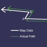
I've also noticed that it still has trouble snapping to the correct waypoint in certain "really close" situations. It's hard to describe, but I'll try.
Imagine the following route (this is an actual example from my route to work in the morning):

A and B are actual waypoints, requiring that I make a turn. In this case, the distance between A and B is very small, perhaps only a hundred feet or so. Maybe less.
The mapping data is pretty accurate for this set of streets, but it's not perfectly aligned with the real GPS readings. So my path is off from the map data, just a little, as you can see.
GPSapp malfunctions on this set of turns. It either tells me about waypoint B much too late (after I'm already executing the turn), or it never stops telling me about waypoint A (requiring me to twiddle the knob to get it tracking properly again).
I understand that the real path isn't exactly on the data path, so I can see why GPSapp is having trouble with it. But I'm wondering if there's any way GPSapp can be more clever about how it snaps to the next waypoint. For example, it might be able to use my heading direction to decide whether or not I've actually executed a turn. Or it could notice that the next two waypoints are really close together, and temporarily "tighten up" its snap distance to make sure that I don't miss the B waypoint.
|
|
Top
|
|
|
|
|
#150775 - 29/03/2003 11:12
Re: GPSapp-0.17
[Re: tfabris]
|
carpal tunnel
Registered: 24/01/2002
Posts: 3937
Loc: Providence, RI
|
You'll probably say you can't, but if you could capture some GPS output through this segment, and give me a route file...
|
|
Top
|
|
|
|
|
#150776 - 29/03/2003 11:15
Re: GPSapp-0.17
[Re: tfabris]
|
carpal tunnel
Registered: 24/01/2002
Posts: 3937
Loc: Providence, RI
|
I should look at the code and see if there are multiple ways we can get altitude. From gpsd I have this vague idea that there are multiple ways which provide a different answer unless you remember to normalize for what the input actually is.
|
|
Top
|
|
|
|
|
#150777 - 29/03/2003 11:22
Re: GPSapp-0.17
[Re: jaharkes]
|
Carpal Tunnel
Registered: 08/02/2002
Posts: 3411
|
Oh, another feature request...
When changing waypoints, can we get an autozoom so that the next waypoint is on the screen at an appropriate scale? I'm guessing that this would need to be a toggleable option.
_________________________
Mk2a 60GB Blue. Serial 030102962
sig.mp3: File Format not Valid.
|
|
Top
|
|
|
|
|
#150778 - 29/03/2003 11:22
Re: GPSapp-0.17
[Re: Daria]
|
carpal tunnel
Registered: 20/12/1999
Posts: 31575
Loc: Seattle, WA
|
You'll probably say you can't, but if you could capture some GPS output through this segment, and give me a route file... How would this be done?
Do you mean stream the serial output from the GPS unit to a file? If that can be done with some kind of softare on the player, I'd be happy to do it.
|
|
Top
|
|
|
|
|
#150779 - 29/03/2003 16:17
Re: GPSapp-0.17
[Re: tfabris]
|
carpal tunnel
Registered: 24/01/2002
Posts: 3937
Loc: Providence, RI
|
Do you mean stream the serial output from the GPS unit to a file?
Yes.
If that can be done with some kind of softare on the player, I'd be happy to do it.
Well, I could write something, but if you wait for that it will probably be a bit. Basically the simple way involves installing gpsd, making it get run by hijack, then installing "nc" (netcat) and a script which runs netcat, connects to gpsd, sends 'R' to enable raw mode, and writes output to a file... but you'll have to pick a partition on your player to mount read-write to do it.
Don't ask me to script it, at least not today.
|
|
Top
|
|
|
|
|
#150780 - 30/03/2003 02:08
Re: GPSapp-0.17
[Re: Daria]
|
pooh-bah

Registered: 31/08/1999
Posts: 1649
Loc: San Carlos, CA
|
Well, I could write something
Or if you have access to a laptop you can just drive the area and capture the nmea output from your gps via hyperterminal (or your preferred serial app). I did this a couple of times when I was testing stuff for Kim's gps software. You could do it with the empeg as well, but you would have to have the drives mounted read/write and it gets more complicated from there.
-Mike
|
|
Top
|
|
|
|
|
#150781 - 30/03/2003 11:05
Re: GPSapp-0.17
[Re: mcomb]
|
carpal tunnel
Registered: 24/01/2002
Posts: 3937
Loc: Providence, RI
|
Yup, but he mounted his GPS in his dash I bet. I suppose if he had another that might work.
|
|
Top
|
|
|
|
|
#150782 - 30/03/2003 12:26
Re: GPSapp-0.17
[Re: Daria]
|
carpal tunnel
Registered: 20/12/1999
Posts: 31575
Loc: Seattle, WA
|
Yup, but he mounted his GPS in his dash I bet. I did. I'm not that adverse to digging in the dash, but it's just a question of getting the time to do that. It's a bit of a project.
The GPSD software solution sounds like one way to go about it, but I know just enough about Linux to make me dangerous, so without some really detailed instructions, I'm loath to attempt it on my own.
|
|
Top
|
|
|
|
|
#150783 - 30/03/2003 12:40
Re: GPSapp-0.17
[Re: tfabris]
|
carpal tunnel
Registered: 24/01/2002
Posts: 3937
Loc: Providence, RI
|
Well, we have broken stuff here, and I have a funeral to go to, and after that, probably Wednesday at earliest I might be able to script something and give you some binaries.
|
|
Top
|
|
|
|
|
#150784 - 30/03/2003 12:44
Re: GPSapp-0.17
[Re: genixia]
|
enthusiast
Registered: 20/08/2002
Posts: 340
Loc: Pittsburgh, PA
|
Ok, got to play with this today. The altitude bug isn't totally fixed. Apparantly I was at 4 billion feet altitude at some point. I know I live on a hill, but it's not that high
And I thought I was dealing with altitude as a signed integer all the way by now. I don't really have a way to test it because the lowest point around here is several hundred feet above sealevel.
Preloading the list of routes at startup would solve the pause when we go into the 'select a route' menu, but I don't see what the use would be when the current stat (actually opendir) is left in place. As soon as we call stat or opendir, the process is stalled until the disk is spun up, it doesn't matter if we use or discard the result.
_________________________
40GB - serial #40104051 gpsapp
|
|
Top
|
|
|
|
|
#150785 - 30/03/2003 12:56
Re: GPSapp-0.17
[Re: tfabris]
|
enthusiast
Registered: 20/08/2002
Posts: 340
Loc: Pittsburgh, PA
|
Was it stuck at some waypoint in the middle of the route? What we do is, first get the distance between 'closest point' and the end of the route. The distances for all points in the route are pre-computed whenever we load the route into memory. And then we add the distance between our current location and that closest point. The number in the top right corner is not an 'as the crow flies' distance to the destination, but the true sum assuming that we will have to pass all waypoints including the currently selected one.
_________________________
40GB - serial #40104051 gpsapp
|
|
Top
|
|
|
|
|
#150786 - 30/03/2003 13:07
Re: GPSapp-0.17
[Re: tfabris]
|
enthusiast
Registered: 20/08/2002
Posts: 340
Loc: Pittsburgh, PA
|
I've also noticed that it still has trouble snapping to the correct waypoint in certain "really close" situations. It's hard to describe, but I'll try.
Yeah, most car navigation systems seem to use a 'trick' for this. They 'snap' the gps reported location to the closest road which has the correct heading. People that go hiking or offroading have to explicitly disable this feature to get correct position reporting.
I don't want to do something like this until we have full street information available. The current routes really don't have that much information and if we snap the current position to a likely place in the route it would be a bit difficult to find the correct route back after a wrong turn.
_________________________
40GB - serial #40104051 gpsapp
|
|
Top
|
|
|
|
|
#150787 - 30/03/2003 13:08
Re: GPSapp-0.17
[Re: jaharkes]
|
carpal tunnel
Registered: 20/12/1999
Posts: 31575
Loc: Seattle, WA
|
Was it stuck at some waypoint in the middle of the route? No, it was tracking my path and correctly displaying the waypoints in the correct order when I observed this behavior.
The number in the top right corner is not an 'as the crow flies' distance to the destination, but the true sum assuming that we will have to pass all waypoints including the currently selected one. Which is the behavior I expected. Only it seemed to be counting upwards away from zero as I approached the destination, not downwards toward zero. The number kept getting higher as I traveled the (correctly tracked) route, not lower.
It really does seem to have gotten its start and end points mixed up for the calculation of that number. It really looked like it was showing me distance-from-start, not distance-to-end.
The other number, the one in the lower right, correctly calculates distance to next waypoint. It's on the upper-right number that I noticed this behavior.
|
|
Top
|
|
|
|
|
#150788 - 30/03/2003 13:12
Re: GPSapp-0.17
[Re: jaharkes]
|
carpal tunnel
Registered: 20/12/1999
Posts: 31575
Loc: Seattle, WA
|
The current routes really don't have that much information and if we snap the current position to a likely place in the route it would be a bit difficult to find the correct route back after a wrong turn. I agree that it would be bad to snap your current position to the map data. Because as we all know, map data can suck pretty often. I like the way it works currently: seeing how far off from reality the map data is.
But maybe, just for the purposes of deciding which waypoint to select and display, it could sort of "assume" a snap? Not for the actual screen display, not for the actual calculations of everything else... just for purpose of choosing when to display the next waypoint.
This would also solve the problem of it saying to turn left when you're clearly looking at a right turn (as we discussed before).
|
|
Top
|
|
|
|
|
#150789 - 30/03/2003 13:21
Re: GPSapp-0.17
[Re: jaharkes]
|
Carpal Tunnel
Registered: 08/02/2002
Posts: 3411
|
Preloading the list of routes at startup would solve the pause when we go into the 'select a route' menu, but I don't see what the use would be when the current stat (actually opendir) is left in place. As soon as we call stat or opendir, the process is stalled until the disk is spun up, it doesn't matter if we use or discard the result
Good point. I wonder if there's any kernel ioctl that can force a spin up with an immediate return?
_________________________
Mk2a 60GB Blue. Serial 030102962
sig.mp3: File Format not Valid.
|
|
Top
|
|
|
|
|
#150790 - 30/03/2003 13:47
Re: GPSapp-0.17
[Re: genixia]
|
enthusiast
Registered: 20/08/2002
Posts: 340
Loc: Pittsburgh, PA
|
Would probably still not be that useful. There isn't much memory and the player mlocks most of it for it's own use. Any codepath that hasn't been executed in a while has a high probability that it was paged out, so it is equally likely that something as simple as a function call is blocking on the disk spinup.
It is fairly easyl to observe, simply run ps auxwww and notice that the RSS size of pretty much every process (except for the player) is significantly smaller than the VM size. When gpsapp is blocked in the hijack waitmenu ioctl, it is completely paged out after a while.
I view this as a good reason to avoid useless and duplicated code. Most problems are avoided when the binary and memory usage are as small as possible. There are limits, with a full streel level database we simply can't avoid disk accesses.
_________________________
40GB - serial #40104051 gpsapp
|
|
Top
|
|
|
|
|
#150791 - 30/03/2003 15:05
Re: GPSapp-0.17
[Re: jaharkes]
|
Carpal Tunnel
Registered: 08/02/2002
Posts: 3411
|
unless gpsapp mlock'd that function...
But at this point, I'd be inclined to agree that the effort wouldn't be justified for just this reason. I do wonder whether it might be worth mlocking just enough of the menu structure so that gpsapp always appears responsive to user input, even if everything else is paged out. But that's another story.
I still think it's worth stating the directory early though. From the usability aspect, people tend to accept delays in loading files more than they do when listing them, and it'd be more consistent with delays elsewhere on the empeg - eg Playlist loading, the delay happens at the load.
_________________________
Mk2a 60GB Blue. Serial 030102962
sig.mp3: File Format not Valid.
|
|
Top
|
|
|
|
|
#150792 - 30/03/2003 15:36
Re: GPSapp-0.17
[Re: tfabris]
|
carpal tunnel

Registered: 25/12/2000
Posts: 16706
Loc: Raleigh, NC US
|
I'm not that adverse to digging in the dash averseI'm loath to attempt it on my own. You got this one right, though. I hate it when people confuse ``loath'' and ``loathe''. As much as when they confuse ``breath'' and ``breathe''.
_________________________
Bitt Faulk
|
|
Top
|
|
|
|
|
#150793 - 30/03/2003 17:13
Re: GPSapp-0.17
[Re: tfabris]
|
addict
Registered: 14/01/2002
Posts: 443
Loc: Raleigh, NC
|
No, it was tracking my path and correctly displaying the waypoints in the correct order when I observed this behavior. Was this in conjunction with it not noticing that you passed a waypoint due to the GPS coordinates being off from the waypoint coordinates? If so, it will count upwards as it assumes you have to go through that "missed" waypoint. As you continue on down the path, you are getting further from that "missed" waypoint, so your total route distance would increase.
If not, then I'm out of ideas..
|
|
Top
|
|
|
|
|
#150794 - 30/03/2003 17:32
Re: GPSapp-0.17
[Re: Yang]
|
carpal tunnel
Registered: 20/12/1999
Posts: 31575
Loc: Seattle, WA
|
Was this in conjunction with it not noticing that you passed a waypoint due to the GPS coordinates being off from the waypoint coordinates? Negative. This was on a different occasion when it was correctly tracking my path.
However, there's a chance that I may have had to twiddle the knob during the start of the trip (i.e., I was already underway when I activated GPSapp, and I twiddled the knob to make it reach the current waypoint).
But when I noticed the "counting up" thing happening, it was tracking correctly and following waypoints correctly.
|
|
Top
|
|
|
|
|
#150797 - 30/03/2003 21:31
Re: GPSapp-0.17
[Re: tfabris]
|
addict
Registered: 14/01/2002
Posts: 443
Loc: Raleigh, NC
|
Correct.. However, if it assumed that you missed a turn, it would consider your forward movement to be going away from the next waypoint. I guess it depends on the difference between the route and your path, and how close to the route you have to be to be considered following the route.
|
|
Top
|
|
|
|
|
#150798 - 30/03/2003 22:11
Re: GPSapp-0.17
[Re: Yang]
|
carpal tunnel
Registered: 20/12/1999
Posts: 31575
Loc: Seattle, WA
|
Lemme clarify what I said... No matter what happened earlier in the trip, even if I got off-track, the software knows that I'm on track *now* and is tracking correctly and showing me that the next waypoint is the correct waypoint. It shows the higlighted section of road (the road ahead of me) correctly. It is correctly counting down the distance to the next correct waypoint.
So, at that point, even if I'd gone off track earlier, the software should be treating it as an "on track, on path" situation, and ignore the fact that I'd strayed earlier in the trip. And should still be counting down the correct distance to both the next waypoint (which it's doing properly) and the end of the route. Not counting up from some old missed waypoint. If that's genuinely what the software is doing, then that's a bug that really needs to be fixed.
|
|
Top
|
|
|
|
|
#150799 - 04/04/2003 12:08
Re: GPSapp-0.17
[Re: tfabris]
|
carpal tunnel
Registered: 20/12/1999
Posts: 31575
Loc: Seattle, WA
|
Update...
When using the new map data set from StreetAtlas with Siberia's method, the distance countdown seems to be working correctly. Perhaps all along it was bad map data?
My only concern is... The map data I was using before, it came right from Jan's supplied Python script. So I don't see why it should be corrupted to the point of causing a program error. Perhaps inaccurate in terms of street information, but not completely corrupted.
And in all cases, when I look at the map data files in an ASCII editor, they all look fine to me.
Hmm...
|
|
Top
|
|
|
|
|
#150800 - 04/04/2003 12:13
Re: GPSapp-0.17
[Re: tfabris]
|
carpal tunnel
Registered: 25/12/2000
Posts: 16706
Loc: Raleigh, NC US
|
What happens if you remove the new .V ir_translate lines? If it goes back to being flaky, what about removing all ir_translate lines? Does Jan have any ir_translate happening?
_________________________
Bitt Faulk
|
|
Top
|
|
|
|
|
|

 Previous Topic
 Index
Index